


Nego
Rp283.600.000,-
PROMO! Hi-Target V90 RTK GNSS MURAH!
View: 276
Category: Electronic Others
Category: Electronic Others
About This Ad
Price: Rp283.600.000,-
Negotiable
Type: Sale
Condition: New
Ads Description:
V90 PLUS GNSS RTK SYSTEM
With a hi-tech, fully integrated design, the conveniently sized V90Plus is one of the most flexible choices for any measuring task. Built-in Linux3.2.0 operating system, pre-loaded multiple smart applications such as tilt surveying, electronic bubble calibration, NFC and voice DIY, V90Plus GNSS system provides surveyor industry-leading GNSS solutions
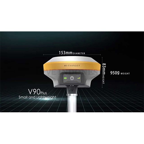
Small and lightweight
Only weighs 950g.
Measures Diameter 153mm x Height 83mm.
Multi-constellation Tracking
220 tracking channels
Supports GPS, GLONASS, GALILEO, BDS, SBAS
NGS approved full-band GNSS antenna
Smart Application
Offers tilt survey with a maximum tilt angle of 30 degrees.
Supports electronic bubble calibration
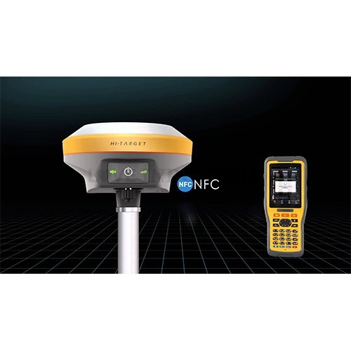
The internal NFC module makes Bluetooth communication quick and easy.
Intelligent voice assistance guides field operations. Voice can be DIY.
Standard Rinex data and HI-TARGET raw data recorded simultaneously.
Optional Transceiver UHF Radio
The transceiver UHF radio enables switchable working modes between base and rover.
Three types of internal UHF radio provide different frequencies based on users requirements. The Pacific Crest TrimTalk© internal UHF radio is compatible with other radios.
Multi-network Connection
Supports GPRS, GSM and WCDMA
Supports WIFI
Powerful Battery
Powered by high-capacity (5000mAh) Li-ion battery to ensure full day operation
Rugged Design
IP67 dustproof and waterproof
Able to survive a 3-meter natural fall onto concrete
Satellite Signals Tracked Simultaneously
220 Channels
GPS……….. Simultaneous L1C/A, L2C, L2E, L5
GLONASS……………..Simultaneous L1C/A, L1P, L2C/A (GLONASS M only), L2P
SBAS……………………. Simultaneous L1 C/A, L5
Galileo………………… Simultaneous L1 BOC, E5A, E5B, E5AltBOC
BDS………………..…….……………………………. B1, B2
QZSS…………………….. L1 C/A, L1 SAIF, L2C, L5
POSITIONING PERFORMANCE
Static and Fast Static GNSS Surveying
Horizontal……………………2.5mm+0.5ppm RMS
Vertical…………………………. 5mm+0.5ppm RMS
Post Processing Kinematic (PPK / Stop & Go) GNSS Surveying
Horizontal……………………….. 1cm+1ppm RMS
Vertical………………………… 2.5cm+1ppm RMS
Initialization time……….Typically 10 minutes for base while 5 minutes for rover
Initialization reliability……Typically > 99.9%
Real Time Kinematic (RTK) Surveying
Single Baseline
Horizontal……………………….. 8mm+1ppm RMS
Vertical…………………………. 15mm+1ppm RMS
Network RTK
Horizontal……………………….. 8mm+0.5ppm RMS
Vertical………………………….. 15mm+0.5ppm RMS
Initialization time……..…Typically < 8seconds
Initialization reliability…….Typically > 99.9%
Code Differential GNSS Positioning
Horizontal………………………. 25cm+1ppm RMS
Vertical…………………………… 50cm+1ppm RMS
SBAS ……… 0.50m Horizontal, 0.85m Vertical
HARDWARE
Physical
Dimensions (W x H)…….153mm x 83mm (6.02inch x 3.27inch)
Weight………950g (2.09lb) without internal battery
Operating temperature………. -40℃to +65℃ (-40℉ to +149℉)
Storage temperature…………. -40℃ to +75℃(-40℉ to +167℉)
Humidity………………………. 100%, considering
Water/dustproof……………….. IP67 dustproof, protected from temporary immersion to depth of 1m (3.28ft).
Shock and vibration……………Designed to survive a 3m(9.84ft) natural fall onto concrete.
Electrical
Power 6V to 28V DC external power input
Power consumption ≤3.5W
Automatic switching between internal power and external power
Rechargeable, removable 7.4V, 5000mAh Lithium-ion battery in internal battery compartment
Internal Battery Life
Static 12hours
RTK rover (UHF/GPRS/3G) 8-10 hours
RTK base 8 hours
I/O Interface
1 xBluetooth, NFC
1 x standard USB2.0 port
1 x TNC antenna connector
1 x RS232 serial port
1 x DC power input (5-pin)
Tilt Survey System
Electronic Bubble
COMMUNICATION
Network Communication
Fully integrated, fully sealed internal WCDMA, compatible with GPRS, GSM
Wifi frequency is 2.4G, supports 802.11b/g/n protocol
Network RTK (via CORS) range20-50km
HI-TARGET Internal UHF Radio(Standard)
Frequency… 450~470MHz with 116 channels
Transmitting power…0.5W, 1W, 2W adjustable
Transmitting speed……….9.6Kbps, 19.2Kbps
Working range………….3~5km typical, 8~10kmoptimal
GET FREE:
- 2 Alumunium tripod,
- 1 set prisma poligon,
- 1 prisma with pole
Rumah GPS menjual berbagai macam peralatan elektronik seperti GPS handheld, GPS mapping, GPS marine, GPS geodetik, GPS navigasi, Telepon satelit, Alat survey, smartwatch, kompas, drone, Laser meter, Teropong, Alat geologi, dan lebih banyak lagi. Rumah GPS menjual produk dengan harga yang murah dan terpercaya.
Website :
www.rumahgps.com
www.larindasurvey.com
Telepon : 0217324948
HP : 081288098069
Whatsapp : 081288098069
BBM : 5B620600
Alamat: Jl. Sunan Kalijaga, No.92, Larangan Indah
Kode pos: 15154
Kota: Tanggerang
Provinsi: Banten
With a hi-tech, fully integrated design, the conveniently sized V90Plus is one of the most flexible choices for any measuring task. Built-in Linux3.2.0 operating system, pre-loaded multiple smart applications such as tilt surveying, electronic bubble calibration, NFC and voice DIY, V90Plus GNSS system provides surveyor industry-leading GNSS solutions
Small and lightweight
Only weighs 950g.
Measures Diameter 153mm x Height 83mm.
Multi-constellation Tracking
220 tracking channels
Supports GPS, GLONASS, GALILEO, BDS, SBAS
NGS approved full-band GNSS antenna
Smart Application
Offers tilt survey with a maximum tilt angle of 30 degrees.
Supports electronic bubble calibration
The internal NFC module makes Bluetooth communication quick and easy.
Intelligent voice assistance guides field operations. Voice can be DIY.
Standard Rinex data and HI-TARGET raw data recorded simultaneously.
Optional Transceiver UHF Radio
The transceiver UHF radio enables switchable working modes between base and rover.
Three types of internal UHF radio provide different frequencies based on users requirements. The Pacific Crest TrimTalk© internal UHF radio is compatible with other radios.
Multi-network Connection
Supports GPRS, GSM and WCDMA
Supports WIFI
Powerful Battery
Powered by high-capacity (5000mAh) Li-ion battery to ensure full day operation
Rugged Design
IP67 dustproof and waterproof
Able to survive a 3-meter natural fall onto concrete
Satellite Signals Tracked Simultaneously
220 Channels
GPS……….. Simultaneous L1C/A, L2C, L2E, L5
GLONASS……………..Simultaneous L1C/A, L1P, L2C/A (GLONASS M only), L2P
SBAS……………………. Simultaneous L1 C/A, L5
Galileo………………… Simultaneous L1 BOC, E5A, E5B, E5AltBOC
BDS………………..…….……………………………. B1, B2
QZSS…………………….. L1 C/A, L1 SAIF, L2C, L5
POSITIONING PERFORMANCE
Static and Fast Static GNSS Surveying
Horizontal……………………2.5mm+0.5ppm RMS
Vertical…………………………. 5mm+0.5ppm RMS
Post Processing Kinematic (PPK / Stop & Go) GNSS Surveying
Horizontal……………………….. 1cm+1ppm RMS
Vertical………………………… 2.5cm+1ppm RMS
Initialization time……….Typically 10 minutes for base while 5 minutes for rover
Initialization reliability……Typically > 99.9%
Real Time Kinematic (RTK) Surveying
Single Baseline
Horizontal……………………….. 8mm+1ppm RMS
Vertical…………………………. 15mm+1ppm RMS
Network RTK
Horizontal……………………….. 8mm+0.5ppm RMS
Vertical………………………….. 15mm+0.5ppm RMS
Initialization time……..…Typically < 8seconds
Initialization reliability…….Typically > 99.9%
Code Differential GNSS Positioning
Horizontal………………………. 25cm+1ppm RMS
Vertical…………………………… 50cm+1ppm RMS
SBAS ……… 0.50m Horizontal, 0.85m Vertical
HARDWARE
Physical
Dimensions (W x H)…….153mm x 83mm (6.02inch x 3.27inch)
Weight………950g (2.09lb) without internal battery
Operating temperature………. -40℃to +65℃ (-40℉ to +149℉)
Storage temperature…………. -40℃ to +75℃(-40℉ to +167℉)
Humidity………………………. 100%, considering
Water/dustproof……………….. IP67 dustproof, protected from temporary immersion to depth of 1m (3.28ft).
Shock and vibration……………Designed to survive a 3m(9.84ft) natural fall onto concrete.
Electrical
Power 6V to 28V DC external power input
Power consumption ≤3.5W
Automatic switching between internal power and external power
Rechargeable, removable 7.4V, 5000mAh Lithium-ion battery in internal battery compartment
Internal Battery Life
Static 12hours
RTK rover (UHF/GPRS/3G) 8-10 hours
RTK base 8 hours
I/O Interface
1 xBluetooth, NFC
1 x standard USB2.0 port
1 x TNC antenna connector
1 x RS232 serial port
1 x DC power input (5-pin)
Tilt Survey System
Electronic Bubble
COMMUNICATION
Network Communication
Fully integrated, fully sealed internal WCDMA, compatible with GPRS, GSM
Wifi frequency is 2.4G, supports 802.11b/g/n protocol
Network RTK (via CORS) range20-50km
HI-TARGET Internal UHF Radio(Standard)
Frequency… 450~470MHz with 116 channels
Transmitting power…0.5W, 1W, 2W adjustable
Transmitting speed……….9.6Kbps, 19.2Kbps
Working range………….3~5km typical, 8~10kmoptimal
GET FREE:
- 2 Alumunium tripod,
- 1 set prisma poligon,
- 1 prisma with pole
Rumah GPS menjual berbagai macam peralatan elektronik seperti GPS handheld, GPS mapping, GPS marine, GPS geodetik, GPS navigasi, Telepon satelit, Alat survey, smartwatch, kompas, drone, Laser meter, Teropong, Alat geologi, dan lebih banyak lagi. Rumah GPS menjual produk dengan harga yang murah dan terpercaya.
Website :
www.rumahgps.com
www.larindasurvey.com
Telepon : 0217324948
HP : 081288098069
Whatsapp : 081288098069
BBM : 5B620600
Alamat: Jl. Sunan Kalijaga, No.92, Larangan Indah
Kode pos: 15154
Kota: Tanggerang
Provinsi: Banten